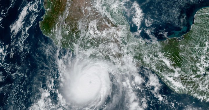
Hurricane Otis slammed into Mexico’s southern Pacific coast as a Category 5 hurricane early Wednesday morning after “rapidly intensifying” in strength in a matter of hours.Residents along the coast of Guerrero state, which includes the beach resort town of Acapulco, scrambled to prepare for the hurricane’s landfall. Meteorologists were expecting Otis to be a tropical storm early Tuesday. In just 12 hours, it strengthened into a dangerous Category 5 hurricane by the day’s end.The National Hurricane Center (NHC) in Miami called it a “nightmare scenario” late Tuesday, measuring maximum sustained winds of 260 km/h.“This is an extremely serious situation for the Acapulco metropolitan area with the core of the destructive hurricane likely to come near or over that large city,” the NHC said. “There are no hurricanes on record even close to this intensity for this part of Mexico.”Story continues below advertisementThe centre warns that Otis could bring life-threatening flooding to the coast with “large and destructive waves,” as well as sustained rainfall that could produce flash flooding and mudslides.Videos of the storm surge in Acapulco were posted to social media overnight and Wednesday morning, showing flooding in the streets and immense property damage. Another video showed horizontal wind and rain battering a group of palm trees outside a hotel.#acapulco #OTIS#HuracanOtis pic.twitter.com/ge9tDya9Tx— Ing. David Hall (@ClintonHaVi) October 25, 2023Devastating scenes of storm surge in #Acapulco, Mexico after Category 5 Hurricane #Otis made landfall overnight pic.twitter.com/gaKFsgF2Hs— Zoom Earth (@zoom_earth) October 25, 2023Story continues below advertisementIn Acapulco, things are getting serious. More and more people are asking for help in connection with the flooding caused by Hurricane Otis#HurricaneOtis #Huracan #Otis #Acapulco #Mexico #HuracánOtis pic.twitter.com/Lmtbzct9G3— Trends on X (@X_TrendsX) October 25, 2023As dawn broke, authorities had given no preliminary damage assessments as much of the area remained without power. Downed trees, persistent rain and flooding made it difficult to move.According to Anthony Farnell, chief meteorologist at Global News, Hurricane Otis has “set a record for the fastest a hurricane has ever intensified,” and nobody saw it coming.“None of the computer modelling predicted anything more than a weak hurricane at landfall,” Farnell said. “A hurricane hunter flight reached the storm late Tuesday afternoon and quickly came to the conclusion that Otis was deepening rapidly and had already attained Category 3 status.”When Otis made landfall, it left a path of destruction in its wake.Story continues below advertisement“The storm surge was devastating into Acapulco and wind damage caused severe structural damage to some buildings,” Farnell said. “Many roads are also washed out or covered in debris, limiting rescue crews.”Through Wednesday morning, Otis weakened to a strong Category 2 storm and is expected to continue diminishing in strength as it reaches Guerrero’s steep mountains farther inland.⚠️#Otis se ha debilitado a huracán categoría 2 ⚠️?A 100 km al nor-noroeste de Acapulco, Guerrero?Vientos máximos sostenidos de 175 km/h?Se desplaza al nor-noroeste a 17 km/hInfórmate solo en fuentes oficiales y no difundas rumores.@laualzua pic.twitter.com/3COkotJPeQ— Coordinación Nacional de Protección Civil (@CNPC_MX) October 25, 2023Trending NowInterest rates on hold — for now. Where does the Bank of Canada go next?Panera sued over ‘Charged Lemonade’ energy drink after college student dies“The hurricane weakened as fast as it intensified today thanks to the very mountainous terrain of southern Mexico,” Farnell added. “But all that rain caused catastrophic flooding.”Dangerous winds and heavy rain in Acapulco and surrounding towns stirred memories of Hurricane Pauline in 1997, which killed more than 200 people and destroyed swaths of the city.Story continues below advertisement“We’re on maximum alert,” Acapulco Mayor Abelina López said Tuesday night as she urged residents to hunker down at home or move to the city’s shelters. She said Otis could be more devastating than hurricane Pauline.President Andrés Manuel López Obrador told people via the platform X, formerly known as Twitter, “to go to shelters, stay in safe places away from rivers, streams, ravines and be alert, without being overconfident.”Canada issued an advisory against all non-essential travel to Mexico’s southern coast between Punta Maldonado and Zihuatanejo in Guerrero state, where a hurricane warning is currently in effect.More on CanadaPaul Bernardo transfer: Prison officials ‘intervened’ to stop public statementSen. Ian Shugart, ex-clerk of the Privy Council, dies at 66Interest rates on hold — for now. Where does the Bank of Canada go next?Air Canada apologizes to British MP held up ‘because his name is Mohammad’West Jet told Global News that its flight operations “remain unimpacted” thus far, but the airline will “continue to monitor Hurricane Otis’ path and will make make operational changes in the name of safety as required.”Air Canada is also monitoring Hurricane Otis “closely,” but the storm has so far not impacted operations.Otis’s maximum sustained winds have decreased to near 175 km/h as of 7 a.m. central time Wednesday morning, the NHC reported. The centre believes the hurricane will “likely dissipate over southern Mexico tonight.”Otis’s arrival came just days after hurricane Norma struck the southern tip of Mexico’s Baja California Peninsula to the north.Story continues below advertisementAs for how Hurricane Otis was able to so rapidly intensify in power, chief meteorologist Farnell believes it may be because the storm passed over a patch of warm water right before hitting Mexico’s coast.“The hurricane moved over some exceptionally warm water right before landfall which was likely at least partially responsible for the rapid intensification. Meteorologists will now need to study what went wrong and try to adjust modelling so that these major mistakes can be avoided in the future,” Farnell said.“It does go to show how much we still don’t know about hurricanes.”— With files from The Associated Press 1:57One year anniversary of Fiona’s devastation in Atlantic CanadaOne year anniversary of Fiona’s devastation in Atlantic CanadaPost-tropical cyclone Lee: More storms ahead in Atlantic hurricane seasonHurricane Lee: Officials urge people to ‘be ready’ as storm approaches MaritimesPrevious VideoNext Video
KUMLUCA HABERLERİ
15 Temmuz 2026GENEL
15 Temmuz 2026GENEL
15 Temmuz 2026GENEL
15 Temmuz 2026KUMLUCA HABERLERİ
15 Temmuz 2026ANTALYA HABERLERİ
15 Temmuz 2026ANTALYA HABERLERİ
15 Temmuz 2026 1
Trump’tan seçim sonrası ilk mülakat
7795 kez okundu
1
Trump’tan seçim sonrası ilk mülakat
7795 kez okundu
 2
Avusturya başbakanı Sebastian Kurz ile ilgili bilinmeyenler
4755 kez okundu
2
Avusturya başbakanı Sebastian Kurz ile ilgili bilinmeyenler
4755 kez okundu
 3
Joe Biden 6 aylık hedeflerini açıkladı. Senato buz gibi…
2865 kez okundu
3
Joe Biden 6 aylık hedeflerini açıkladı. Senato buz gibi…
2865 kez okundu
 4
Putin’den Ermenistan’ı yıkan açıklama: Karabağ Azerbaycan’ın ayrılmaz bir parçasıdır!
1940 kez okundu
4
Putin’den Ermenistan’ı yıkan açıklama: Karabağ Azerbaycan’ın ayrılmaz bir parçasıdır!
1940 kez okundu
 5
Kıvanç Tatlıtuğ’dan evliliğine dair çok çarpıcı röportaj.
1825 kez okundu
5
Kıvanç Tatlıtuğ’dan evliliğine dair çok çarpıcı röportaj.
1825 kez okundu